| Back to History The Church The Churchyard Places of Interest Robert Liston Industry Snippets Old Photo's/Postcards |
Old Maps
Below is a list of the old maps we have managed to source with some brief information about them.
It should be noted that these maps are reproduced by permission of the Trustees of the National
Library of Scotland and that they are extracts from the full maps. Please do not ask us for
copies or further extensions to the areas shown on the images on this site, firstly we cannot grant
permission to copy, secondly the storage space on our server and download speed on connections would
make larger and more detailed images difficult.
If you click on the thumbnail picture a new window will open and the image will load, once the window opens you will have the option to view the next map in the sequence or close it.
|
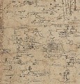
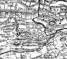
C1583-96 Rough Sketch of West Lothian - Timothy Pont.
This is not a Pont map but the notes and sketches he made to draw a map, the original map of the Lothians does not seem to have survived. Pont's maps and notes were edited by Robert and James Gordon in the period 1630-40 for inclusion J&C Blaeu's Atlas Novus. Note that the village is spelt Inchmachan. |
| |
|
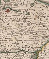
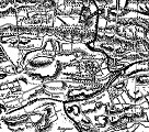
1654 Map of Lothian and Linlithgow - J & C Blaeu.
This is an extract from a beautifully illustrated and detailed colour map. Drawn at a scale of 1 Scottish Mile to 1 inch it was part of the 5th volume of the atlas published in Amsterdam in 1854 (the first atlas of Scotland). Again note that the village is spelt Inchmachan. |
| |
|
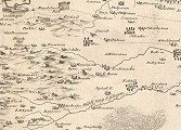
1737 Map of West Lothian - J. Adair.
Drawn in a similar manner to the previous map (as far as detail and content), not coloured in the same fashion but more attention made to the landscape. Note that village appears as Ecclesmachan. Mr. J. Adair was an Edinburgh based surveyor but he surveyed all over Scotland his works included some coastal maps. |
| |
|
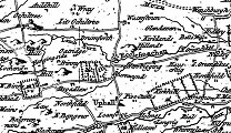
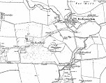
1773 Map of the 3 Lothians - A&M Armstrong.
This map, although in black & white, contains more detail (i.e. more placenames, roads and attention to estate lands). Note the appearance of Oatridge and Burnwynd (now Wyndford), also the position of the road from Greendykes to Ecclesmachan in a more northerly position than its current route (close to the burn in the valley). Andrew Armstrong and his son Mostyn surveyed mostly county maps, although they also did some work surveying the 'post roads'. As well as surveying some Scottish counties they worked on county projects in England and Wales. |
| |
|
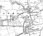
1818 Map of Linlithgowshire - W. Forrest.
Again this map is black & white and a stage more detailed, with an emphasis on land contours and trees etc. Note the position of the road from Greendykes to Ecclesmachan is now further south at its current position. Mr. W. Forrest was also a county surveyor; most of his work being produced C1780-1825. He was renowned for his care and attention to minute detail; most of his work was in central Scotland. |
| |
|
1820 Map of Linlithgowshire - J. Thomson.
Also in black & white and fairly detailed, very similar in style to the previous map by W. Forrest, but perhaps not so finely illustrated. Mr. J. Thomson was a cartographer and mapmaker based in Edinburgh, (although it is said he was originally a bookseller). He produced the first atlas of Scotland since the publication of the Blaeu atlas (1654) and also published maps of Europe, Africa, Asia and America. |
| |
|
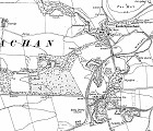
1854 Ordnance Survey Map of Linlithgowshire.
This is the first O/S map of the area and adds real detail to the area of that time. Note the position of the main road through the village, curving down round the old bridge and back to the east lodge of the Binny estate. You can also see annotation for 6 old or current quarries in the immediate vicinity. |
| |
|
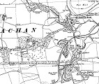
1897 Ordnance Survey Map of Linlithgowshire.
From the second O/S survey and carries a little more detail than the previous and includes contour lines. We can see from this map that the road in the village has now been straightened, the burn has been diverted and that the new churchyard has been established to the south-west. We can also see the appearance of Carldubs shale mine, Binny brick works and the mineral railway. |
| |
|
1922 Ordnance Survey Map of Linlithgowshire.
This third survey map carries a stage more detail again, from it we can see that all the quarries in the area are marked as 'old' or 'disused', the reference to Binny brick works has gone and that Carldubs shale mine has increased in size. |
| |
1952 Ordnance Survey Map of Linlithgowshire.
This fourth survey map shows that there was very little change in the area between 1922 and 1952. Of note are the appearance of two houses just opposite Binny east lodge (at the side of the main road a few hundred feet to the south of the church). Carldubs shale mine is now shown as disused, some of the buildings have disappeared and that section of the mineral railway has gone. There also seems to have been some activity with tree planting just to the west of Binny house stables. |
| |
| Copyright © 2011: Ecclesmachan.org.uk |